


Le Rozier

Maca8284
User
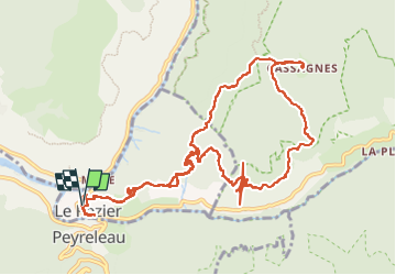

Length
17.2 km

Max alt
883 m

Uphill gradient
1402 m
Km-Effort
36 km

Min alt
398 m

Downhill gradient
1402 m
Boucle
Yes
Creation date :
2014-12-10 00:00:00.0
Updated on :
2014-12-10 00:00:00.0
5h58
Difficulty : Medium

FREE GPS app for hiking
 SityTrail
IGN / Geographical institutes
SityTrail Plus
The world is yours!
About
Trail Walking of 17.2 km to be discovered at Occitania, Lozère, Le Rozier. This trail is proposed by Maca8284.
Description
Gorges de la Jonte et du Tarn.
Positioning
Country:
France
Region :
Occitania
Department/Province :
Lozère
Municipality :
Le Rozier
Location:
Unknown
Start:(Dec)
Start:(UTM)
516565 ; 4893184 (31T) N.
Comments